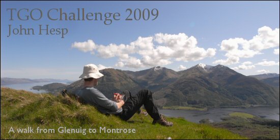
Day 1 - Friday
Press F11 to view full screen.
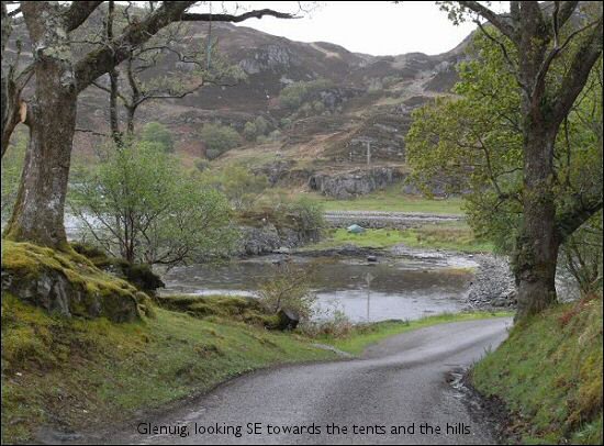
Up at 7:30 and made use of the wonderful Glenuig community hall which has toilet facilities and even showers. Part of the appeal of Scotland for me is that it’s a land of mysteries. Why has a village of five or six houses got such a sumptuous community hall?
Of the third person who was starting at Glenuig there was no sign, but he would no doubt be starting later, or even on Saturday or Sunday. There were approx 350 people doing the Challenge this year, setting off from thirteen start points on the west coast. My arithmetic makes that an average of 27 Challengers per start point, so why were only three starting from Glenuig? I had a feeling we were about to find out, but why was I starting at Glenuig?
I wanted to start from somewhere that had a view of the open sea in order to get that real west coast feel. In fact if the weather had been good I’d planned to camp a little further west at Smirisary for an even better westerly view.
Also, I really like this corner of Scotland, and the natural route from Glenuig is a superb ridge walk which eventually drops down to Glenfinnan. One of the criticisms of this start point is that this ridge makes for a very hard first day, but I’d been on part of the ridge a couple of years earlier so had a good idea of how hard I’d find it to get to the first good camping spot, a bealach (bealach = pass) two thirds of the way along.
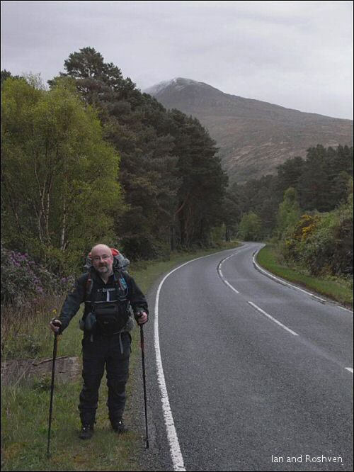
My note book says we left at eight. That seems a remarkably quick getaway for me, but I know we left well before nine because I questioned Ian whether we should leave before the stipulated nine o’clock. In any case Ian phoned up Roger to let him know the two of us were setting off, and we set off along the A861 towards Roshven. For those not familiar with Scottish roads and who might be thinking that the A861 on a Friday morning sounds like it might be nose to tail traffic travelling at 70mph, we were passed by about a dozen cars in four miles.
The road walk was by no means unpleasant. To our left was the rather choppy Sound of Arisaig and later Loch Ailort, whilst to our right steep ground rose up to Cruach Bhrochdadail. I’ll be mentioning place names as often as I can, as although I can’t pronounce them, they look like they sound like the landscape. I love them.
A couple of times we passed caravans wedged into unlikely places just off the road, and which looked like they’d been there a long time. Great sea views. I wondered what the chances of such a thing happening in England would be.
Ian and I seemed to have a lot to chat about. The previous evening Ian had been suggesting we take the good weather route along the ridge if the weather improved, as was forecast. It certainly wasn’t so windy today, although still pretty grim, but Ian was all for for doing the ridge.
Ian pointed out that after all the rain that had fallen in the past week my Foul Weather Alternative route (FWA) would cross many swollen rivers. I liked the irony of foul weather ruling out the foul weather alternative route, and I agreed to have a look at things when we got nearer the first hill – Roshven. (Future Glenuig starters might like to know that there is (was?) a bridge over the Allt a’ Bhuiridh at about 778 812.) However, I couldn’t help remembering that when I’d done part of the ridge a couple of years before it had been a very tiring day – and that was in glorious sunny weather with a day pack. Nonetheless, when we did get a good view of Roshven and it only appeared to be slightly snow covered I decided that I hadn’t come all this way to walk along a road and agreed to join Ian on the ridge.
Having made that decision we set off along the road again in fine spirits. In fact we were so engrossed in our conversation that we walked much further along the road than we should have and realising our mistake had to climb over a fence and struggle up through a very steep wood to reach the slopes of Roshven. If taking he wrong turn so early in the walk was a bit worrying, the scramble up through the wood was great fun - we had to pull ourselves up with our hands it was so steep.
Emerging from the wood we followed a natural line up and to the right until we got onto the ridge from where it was just a very long slog up a steep slope to the top. The views made it necessary to stop frequently.

Just before the top Ian shouted “Ptarmigan!” and I turned to see something that seemed all wings, claws and beak plummeting to the ground. To be fair it was hardly ideal flying conditions.


If at sea level it had seemed that the wind was easing off, up here it was still blowing half a gale. There was only a scattering of snow but the cairn was nicely iced up.

Roshven, or more correctly, Rois-Bheinn, is 2895’ (878m). Not a tremendous height, but we had climbed all the way from sea level. We’d entered cloud before reaching the top, and were to be in it for most of the rest of the day. We set off in an easterly direction and straight away found that whilst the seaward windblown side of the hill, the side we were looking at from below, only had a scattering of snow, the leeward side had enough snow to make things decidedly slippery, and we were both to have our feet shoot out from under us several times before the day was done. Given the alarmingly steep drops that sometimes appeared to either side this made it necessary to proceed with caution.
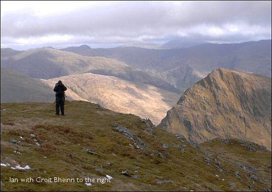
The drop from Roshven to the Bealach an Fiona (2313’ 701m) seemed much further, and a much greater drop than I remembered, and this was the case all day, partly I suppose because of us having to travel slowly and carefully. There’s a wall with fence posts set in it all the way from the bealach (and beyond) up to the summit of Rois-Bheinn. It was hard to imagine people coming up here every day to construct it.
We stopped for lunch when we dropped down out of the cloud at the Bealach an Fiona. Ian disappeared in a southerly direction down one side of the bealach in search of water. I sat munching oat cakes and flapjack watching the cloud race across the cliffs of An Stac. Ian must have had to go quite a way as he was gone some time, and I was getting cold when he came back and was only too glad to push on at his suggestion.
The very steep pull up to Sgurr na Ba Glaise warmed me up a little, but I’d already realised I’d left one important bit of kit at home – a pair of gloves. I was still quite cold when we reached the summit (I was wearing a Silk Body baselayer, Paramo Mountain Vent mid layer, Paramo Viento waterproof, Paramo Cascada trousers and Terra Nova beanie hat [courtesy of a TGO subscription offer]). The Pacerpoles were a great help up the steep, but the backs of my hands were getting stung by the hail. Ian took a photo of the summit with me stood beside it, and I can remember thinking “Come on Ian, it’s freezing”.
The ridge is very defined, there was a path leading off in the right direction and I wanted to get moving again to warm up, so I just headed off down the path as soon as we were ready. A classic mistake, and my mistake. We hadn’t gone 50m when I stopped and said to Ian “Time to get the compass out”. It’s funny how one knows that things don’t look right when everything looks more or less the same – this was one of those occasions. We were heading too far to the south. I led back up towards the cairn again, but before I got there Ian shouted “No need to go all the way back”. His greater experience had picked out the correct way, and we headed of in the correct direction compass in hands.
A bit further on the ridge suddenly turns north, and feeling chastised by my earlier mistake we were overcautious and kept thinking we’d got to the turning point. The turning point has a lochan perched right on the edge of the ridge and we kept thinking every puddle we found was the lochan. I think we were travelling much slower than we thought due to the cloud, very rough terrain and the snow and ice. We even resorted to GPS to see why these puddles didn’t seem to match up with the map.
Eventually the lochan did appear, and I set off to the north. However the terrain is so bumpy and rocky that’s it’s not possible to walk in a straight line, and what with walking round boulders and scrambling over rocky bits I soon had to guiltily tell Ian that we were headed west instead of north. Again we’d only gone 50m or so. More GPS/map work and we headed off again.
This time we got it right and some time later arrived at the summit of Druim Fiaclach (The Notched Ridge). I have a photo of me sitting happily on the summit in blazing sunshine a couple of years earlier. I don’t know about Ian, but on this day I was now just relieved that it was an easy downhill to the bealach where we were to camp. “Downhill all the way to Montrose Ian” I joked, “Not quite” he replied. How true his words were to prove.
When I had walked the ridge a couple of years earlier I’d gained the ridge at Druim Fiaclach (where we now were) and then headed west. I’d only glanced at the ridge heading east and it’d seemed quite straightforward. The map also gives no indication of problems, but after a few hundred metres the ridge became very craggy with no obvious way forward. Luckily we were below the cloud now so we could see the problems quite well, but neither of us wanted to scramble down a crag without knowing if we could get to the bottom. Ian decided to try and flank the ridge whilst I carried on down the ridge being careful not to descend anything I couldn’t scramble back up. From memory, neither of the accounts of walking the ridge I’d read had mentioned any need to outflank the crags. It actually wasn’t as bad as it looked from above. I waited for Ian to appear round the side of the rocks, but eventually he appeared back at the top of the crag, unable to outflank it, and came down the way I had whilst I shouted encouragement (Ian has a very expensive looking camera which wouldn’t like falling down a crag) and pointed the way with a Pacerpole.

Now at last the way was surely clear to get down to the bealach. Yes it was, but the 1300’ (400m) descent really took it out of me. The bealach (at 1150’ 350m) is quite flat and from above looked like it might be a bit boggy for a camp, but again Ian’s experience suggested that the ground would be drier at the edge of the bealach, where it plunges down 800’ (240m) to Glen Aladale, and particularly in a crook of the river where it leaves heavier deposits – something I was to remember for the rest of the trip. He pointed out a likely spot which we made for.
The spot he’d chosen from above was good, so at 7pm it was tents up, put the dinner on (home dehydrated sauce with cous cous), and a book (an easy to read James Herriot) whilst the dinner rehydrated. Then cups of tea with various nibbles whilst I wrote up the day’s notes, looked at the map, and read more about the unlikely places vets put their arms. I settled down to sleep at about 9:30 listening to the rain on the tent a few inches above my face.

Day 02 Intro