Day 2 Saturday _ FWA
I was up and about at about 7:30. It was a cold, dark wet morning and the cloud was even lower than yesterday. Today’s plan was to continue along the ridge to Glenfinnan and then either camp on the SE shore of Loch Shiel, or if the weather was bad, walk over into Cona Glen. If we thought the weather was too bad this morning we could descend to Glenfinnan from our bealach, but after breakfast I made preparations in case Ian was continuing along the ridge. The weather was worse, but I’d certainly go along with him if he was going. Yesterday I’d let Ian do the GPS work because I found that with my map securely folded up in the map case on the back of the OMM Trio front pouch the grid numbers weren’t visible. I wrote the grid numbers on the map around the area we’d be passing through, also bearings of the route off each of the tops. I wasn’t going to make that mistake again – at least, not today. I then wandered about the site a little, looking down into lonely Glen Aladale and taking a few photos of the tents.


A voice from Ian’s tent said “I think it’s a Foul Weather Alternative day”. “I agree” I replied. No need for those map preparations I’d done then, but I was relieved. I was still tired from yesterday, and whilst the first peak, Beinn Mhic Cedidh, which rose directly from the campsite, looked navigationally simple it was a 1200’ (380m) ascent followed by a 800’ (250m) descent. A brutal start to the day. From there another 1200’ ascent led to Beinn Odhar Bheag from where the ridge wound about in a way guaranteed to give slow, frustrating going.
“When will you be ready Ian?”
“Thirty minutes.”
“Perfect.”
Fifty minutes later we were on our way, first finding a place we could jump across the burn without taking our boots off, then along the eastern side of the bealach above the bogs, and then north past Lochan Feith Easain and the descent down to Loch Eilt.

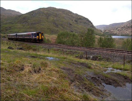
We cut across behind Sgurr na Paite and found a quad bike track to follow down, across the Allt a Bhuide Choir (stream of the yellow corrie – “allt” = stream or river) and down to the railway which I’d travelled along a couple of days ago. I’d thought the ridge impossible then, but thanks to Ian we’d done most of it.
We stopped for a rest beside the railway, and we were just pondering the probability of a train being on this length of track, given there are only about six trains a day, and they take a couple of minutes to round this loop, when a train obligingly appeared. There followed a mad scramble for cameras, a brief glimpse of the warmer, drier world of people in a railway carriage, and then it was gone.
We followed the track on, under the railway, then across the flat bottom of the glen towards the Lochailort to Glenfinnan road. Just before the road we came to the Allt Lon a Mhuide feeding into Loch Eilt. Our feet were so wet by now that we just walked across and took our boots off on the other side to empty out the water.
There followed a few miles of road walking into Glenfinnan, but this wasn’t too bad. The road was surprisingly quiet, there was lots to look at, and it made a change to put ones feet on something solid, dry and level.
After a while a couple of Challengers hove into view ahead and we put on a bit more speed to catch them up. Andrew and Eileen Partington from St Tudy in Cornwall had started from Lochailort that morning and had been advised that the route to Glenfinnan north of the road would be difficult due to swollen rivers, so like us had opted for the road route. Note that setting off from Glenuig you find yourself walking with people who set of from another start point a day later. I love the west so an extra day in the west is a bonus, but some might see this as putting yourself a day behind.
These were the first Challengers I’d “run into” on the walk, and this chance meeting of like minded people turns out to be one of the delights of the Challenge. The fact that you’re both doing the Challenge knocks down all the usual barriers and puts you on best friends terms straight away. Having somebody new to talk to also made the last mile into Glenfinnan easy.
We all went into the National Trust visitor centre cafe at Glenfinnan. There was a bit of excitement here as Ian met people he’d met on previous Challenges. Some of them seemed to be doing the Challenge but were just leaving, but a couple more were people who’d unsuccessfully applied for the Challenge, and were doing the Cape Wrath Trail instead. It seems another Challenge routine is that if you come across somewhere with food for sale buy it.
Eileen, Andrew, Ian and I settled down with various things to eat. I had lentil soup and then a massive piece of iced walnut cake and raspberry tea. I found the “buy food if you see it” idea very easy to get used to.
After an hour or so Eileen and Andrew set off north up Glen Finnan to Corryhully, and Ian set off along the road a bit further to turn north up Gleann Dubh Lighe. I stayed on a bit longer relishing the contrast between the wilds and the delights of a chair with a backrest.
This also gave me a chance to work out my route ahead. If the weather had been good the plan was to walk down the south east shore of Loch Shiel (which Glenfinnan is at the head of), and then the next day walk over a few mountains to drop down into Cona Glen. Ian had got a weather forecast on his phone in Glenfinnan, and it had said the weather was improving, but how much it was improving was hard to say, and the mountains would still be covered in snow, and I’d be on my own.
If the weather was bad my plan was to shortcut these mountains and walk up the glen east of these mountains, Glen Callop, and then into Cona Glen. This would put me half a day, or even a day ahead. Some might see this as a good thing, but I wanted to stay in the west as long as possible, and I particularly wanted to go over the mountains to the SE of Loch Shiel.

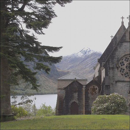
In the end caution prevailed and I decided to take the shortcut to Cona Glen and putting my pack on I walked down towards the monument at the head of the loch. Before the monument is reached a new path turns left and crosses the Callop River by a new bridge just where the river enters the loch. Loch Shiel, a freshwater loch, is about fifteen miles long, and only about 15’ (4m) above sea level. A day and a half’s walking had almost brought me back to sea level.

From the bridge a left turn follows the Callop River up to Callop. Here I found that extensive work had been done installing quite a large Hydro plant. A new track for this installation had been built up the glen which made for easy, if quite dull walking. Nearing the water intake a sign was stuck in the bank of the track saying “Hill Walkers”. I found this sign rather amusing as it didn’t seem to mean anything, so took a picture and carried on up the track. I found the track stopped at the water intake a little further on, and there was no way ahead, so suspecting that maybe the sign I had seen did indicate something I went back to have a closer look. Sure enough, at the top of the very muddy bank a footpath was visible and the sign was kindly informing walkers that the footpath had been destroyed here, but if walkers cared to scramble up a liquid mud bank they could regain the footpath. I’m all for renewable energy, but landowners can’t be allowed to ignore the needs of other legitimate land users, this will only cause bad feeling.

Scaling the muddy bank I set off up the glen again. After a while I came across a side stream which was running quite full. There was no obvious easy way across, but rather than wade I managed to get across on a fallen tree trunk. From here the path rises steeply and then enters an upper glen which is quite different from the lower wooded glen. It started raining again here, and we were to get showers for the rest of the day. The walking was good though. There was a good path and I was able to make good time. Rising steeply from the glen on my right was the Corbett (mountain between 2500 and 3000’) Sgorr Croabh a’ Chaorain, its head in the cloud.
At the head of the glen one finds oneself looking down into the next glen – Cona Glen – with the Corbetts Sgurr Ghubhsachain and Druim Tarsuinn ringing the head of the glen. The name Druim Tarsuinn (transverse ridge) looks like a borrowed name from the ridge adjoining the peak. These, and Sgorr Croabh a’ Chaorain were to be my hills of tomorrow if the weather hadn’t been so bad. They certainly didn’t look very inviting today, and I was glad I’d taken the easy option.
A good path angled down the north side of Cona Glen and then became a track following the river. I decided that as it was still early, and as this upper glen looked pretty austere on this rainy afternoon I’d carry on down the glen until I found a less bleak campsite. A couple of miles down the glen, where it starts to get more wooded I found a site beside the river and put the tent up. It was six thirty.

Dinner was a bit of an experiment, dried mashed potato from my brother in France, thanks Ralph. I’d read somewhere on the www that French dried mash is better than English, but as far as I could taste this might be just the British preference for all things continental. The experiment was really the stuff I’d chucked into another bag at home – TVP, dried onion, dried garlic, Marigold powder and dried herbs. I’m sure that many would turn their noses up at this, but after having walked for ten hours over rough country in poor weather I found the oversize portion I’d made very welcome.

I spent the evening making enormous cups of tea and reading my book. I had that carefree, relaxed Saturday evening feeling. The sun put in an occasional appearance between the showers. The weather was improving.
Day 03 Intro