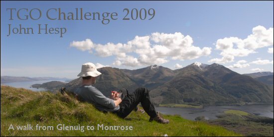
Day 5 Tuesday
I’d quite liked the idea of passing through Kinlochleven. I was interested to see what kind of place this was that was literally on the road to nowhere, tucked away under the mountains such that it hardly saw the sun in winter, and had until recently been so dependent on the aluminium works. The aluminium works had closed down a few years ago and I was curious to see how the place had survived this bombshell. Or maybe it hadn’t.
I was up at seven putting as much excess stuff back in the parcel as I could, and giving the rest to James I left the campsite at nine, and walked round to Kinlochleven proper. I say “proper” because the map shows the part of the village to the north of the river as Kinlochmore, and the part to the south as Kinlochleven. Kinlochmore seemed largely made up of houses, although I did pass a fish and chip shop. A fish and chip shop whose clients are almost exclusively west coast locals would be worth investigating another time.
I liked Kinlochleven. Of course it was a sunny day, but the people I saw and talked to all seemed happy, and the place had none of the devastation and squalor that can be seen in other deserted industrial towns and villages. My interest wasn’t to see a place in crisis, but to see how people re-invent their lives in a more interesting and exciting way.
I passed the Ice Factor, an indoor ice climbing venue which had taken over part of the old aluminium works, and decided to have a second breakfast in their café. But then I passed a Coop and decided I’d go in there after posting my parcel which was starting to feel very heavy, and buy some stuff for a slap-up morning snack and a proper lunch.
The Post Office looked a bit shabby in a good way, and when I passed my parcel to the person behind the counter he immediately guessed that I was on the TGO Challenge and started talking about other Challengers who’d passed through. It seemed I was a day behind most other Challengers, despite my being a day ahead of my original schedule. (I’d originally planned to take five days to reach Kinlochleven but had got a day ahead at Glenfinnan by missing out the mountains to the SE of Loch Shiel). He even talked at length about the blogs some Challengers were writing as they walked. Obviously the Challenge doesn’t go un-noticed.

I think he said the parcel weighed 4.5kg, and it cost nine pounds something to send home. I felt a bit of a fool having paid to have a parcel of food sent from Somerset to Scotland, and then paying again to have it sent back home, especially as there was a good Coop just a few yards away, but the parcels did contain other stuff (books, batteries, maps etc).
Back at the Coop there were a few other rucksacks parked outside. These were most likely West Highland Way walkers, but we were all to interested in food to get into conversation. What to buy when faced with a shop (even a Highland shop) full of goodies? I spent quite a long time picking up things and then putting them back. Pre-packed sandwiches were an obvious choice, but what about getting some cheese and making my own? Then I saw exactly the thing required, some sliced Aberdeen Angus beef. I got coleslaw, spring onions and four white rolls to go with this, and some other goodies as well.
There was a bit of delay leaving as one of the two tills didn’t work, and the shop was quite busy, but when I got out I decided to visit the Ice Factor and see if they had a shop which sold outdoor gear. I needed a pair of rubber caps for my Pacerpoles (trekking poles) for the road walking I’d be doing in a few days time.
The Ice Factor did have a shop, and it was open, and they did have the required rubber bits, but the till didn’t work, and this time there was only one till. What fun, a shop where you can’t buy anything. I loved it, and found the laid back attitude to business in the Highlands very refreshing. The rubber bits cost Ł5.99 and the shop assistant took my ten pound note somewhere to see if he could get change. After a while he came back and said he couldn’t get change, but whilst he’d been gone I’d looked to see just how much change I had.
“I’ve got Ł4.14 in change” I said.
After a long pause he said “Okay”, and we parted, both happy with our 21st century haggling. I was to be very glad of the rubber caps when road walking further east, but to my surprise I was to find them useful later that morning. (The rubber caps go over the tungsten ends of the poles and give a better grip on hard surfaces).
The interesting shopping, the sunshine and the feeling of setting off into the unknown (I only had a vague idea of the geography east of here) put me in a happy, holiday mood, and crossing back over the River Leven I looked at the map to see the way ahead. Today’s plan was to walk up the north bank of the wooded River Leven to the Blackwater Dam and then strike off NE across the moor to Loch Chiarain where I would climb over Leum Uilleim (Corbett 2971’ 909m) and then drop down to camp near Corrour Station.
The way out of Kinlochleven was clear enough, just walk through the houses on the north bank of the river and a path would lead on up the river. But just as I entered the housing estate an elderly couple came out of a house and feeling very pleased with the world, and not wishing to miss a chance to chat to a local I asked them if I was going the correct way. Donny and Sylvia told me they were walking a few hundred yards that way, and they would point out the route from there on, so we walked up the road together. Donny had grown up in Kinlochleven but had moved south when a young man, married Sylvia, and now lived in Barnet. They came up to Kinlochleven as often as possible to stay with Donny’s sister.
My first question to Donny was about the aluminium works and he was able to tell me much about it. I asked why water was still pouring out of the tailrace and he told me that the hydro-electric turbines were still in use selling electricity to the grid. There was actually more water exiting the tailrace than coming down the river, but Donny assured me that the scandal was that the generators only produced about 10% of their capacity. When I got home I checked and in fact the plant has worked at 95% capacity for several years, a surprisingly high figure, and most of the electricity is used by the aluminium works in Fort William, the excess being sold to the grid, which might be where the confusion comes from.
I liked Donny, his local knowledge was interesting, and he was able to tell me about his early days in Kinlochleven. At the next bridge he assured me that a better route than walking up the river was to cross to the south bank and follow the access track up to the dam. I could then cross the dam and continue my walk. I was so pleased at meeting this local expert that I agreed that his plan sounded better than mine and set off across the bridge.
The first thing I saw on crossing the river was the enormous row of pipes coming down the hill and feeding the generators. Putting my carrier bag of food from the Coop down on the ground I jumped up onto the first pipe and made my way to the middle pipe to get a photo of them coming down the hill.

It only took a few seconds but no sooner had I taken a picture than I heard a rustling from the direction of my food bag, and hopping back from pipe to pipe I saw a dog with his nose in my bag. I jumped down and shouted and it ran off to its owner. Looking at the damage I found it’d just nibbled one roll, so I chucked it away, cursed the dog and its owner and set off up the access track.
After a while I came to a place where the pipes came over the brow of a hill and took some more photos. I was amazed at the scale of this pipework and the difficulty that must have been encountered in installing it over such steep ground back in 1909. As if that wasn’t difficult enough they’d also built a dam and a factory, and in those days Kinlochleven would have been virtually inaccessible except by sea.

A mile and a half (2km) out of Kinlochleven I came to some buildings and the place where the leat entered the pipes. Just after leaving the buildings behind I stopped to receive a text from Dom, my brother, and having replied I noticed another track down the slope below me. Perhaps that was the track I should be on? I decided it was and scrambled down to it. In fact I found it was a concrete slabs covering the leat, and I decided that as long as the leat stayed covered I would be better walking along this as it was smooth and level. The thought of falling through into the leat was a bit horrifying, but the concrete seemed solid enough. I got the rubber ends for the Pacerpoles out and carried on walking.

After a couple of miles of leat walking I stopped for my long awaited snack – a roll with beef, coleslaw and spring onions. I’d just started eating when a couple with a dog appeared, walking along the leat. I fended off the dog as best I could and finished eating. I caught them up a little later and they and their dog were very friendly. They were from Somerset too and knew my area. They were walking up to see the dam. I walked with them, but as we neared the dam I said goodbye and turned off up to the right to get to the south end of the dam in order to cross it as recommended by Donny.
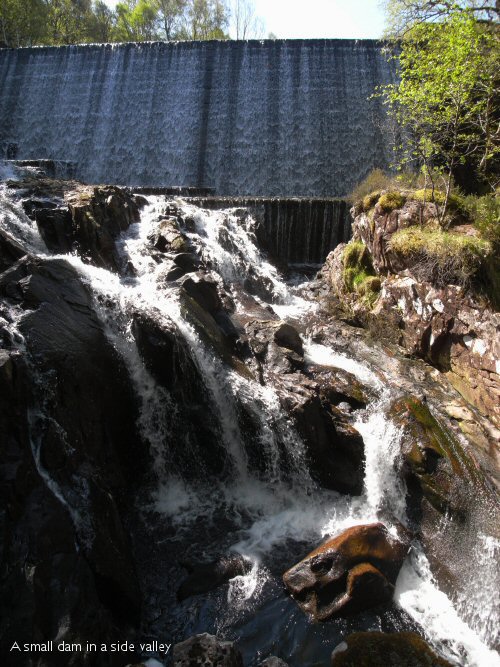
Imagine my horror on getting a good view of the dam to find that the strong east wind was blowing water over the top of the dam in cascades. A closer look also revealed a locked gate at the end of the dam to stop anybody trying to cross. I reflected that it was probably thirty or forty years since Donny had crossed the dam.
Following the track back down to the leat I met the couple from Somerset again and they were a bit alarmed to hear that I was going to see if I could cross the river. The river looked crossable from a distance, but wherever I looked more closely there was always one deep fast bit to negotiate which put me off a bit.

Although the river doesn’t look that big in the photo all that water coming over the dam is coming down the river.
It occurred to me that as the water was coming over the centre few hundred yards of the dam the river would probably be very wide and shallow right under the dam. This proved to be almost correct. In fact it proved to be many small deep fast streams between large rocks, but I noticed that there was a ledge running along the bottom of the dam along which it might be possible to walk. The problem was that as a wave came over the top of the dam it would run down the face of the dam and hit this ledge and then run off onto the rocks below to form the river. I didn’t like the look or sound of the water cascading down the face of the dam, as much as anything it gave me an odd sense of vertigo, but it seemed my best bet.

I have to admit to being rather scared as I jumped onto the ledge and set off along it at a fast but careful pace. I tensed up on hearing the first wave above me, but although I found myself walking through several inches of water a few seconds later, it was obviously wasn’t dangerous, and I wasn’t swept off my feet.
I was expecting things to get better as I got further across, but in fact things got worse. The concrete ledge started angling up the side of the valley, and instead of the water running straight off, it was running down the ledge in a torrent. Soon it got too deep and fast so I jumped off the ledge back onto the bedrock and made my way up to dry ground jumping from rock to rock.
When I reached ‘safety’ I stopped for a rest and food and took my boots and socks off to dry. It was quite spectacular looking back at the water pouring down the face of the dam, and I was quite pleased with my little adventure. Thanks Donny.

From the north end of the dam I followed a path for a while, but it either petered out or I just lost it, and I found myself making my way across bumps of moorland with dips of bog between. I saw a particularly high bump ahead so made for that so that I could better see the way ahead, and from there I could see the path following the bank of the Allt an Inbhir. I followed this good path up to Loch Chiarain where I found a very nice bothy tucked into the side of the hill.

I stopped here for a break, first having a look round the bothy and then sitting outside on the front “lawn” and eating a beef roll with lashings of coleslaw.
As I was eating them another Challenger appeared and introduced himself as John Burt and I immediately recognised the name of the third person to start from Glenuig. He’d actually left Glenuig along a route I hadn’t considered, leaving Glenuig at lunchtime on Friday (a few hours after us), and walking south along the road to Loch Moidart and then to Dalelia where he’d arranged for a boat to take him across Loch Shiel. The boatman had asked him where he was going to camp that night and had invited John to spend the night in his bunkhouse, far from any road on the side of Loch Shiel, and then took John onto Polloch on the east bank of Loch Shiel next morning.
John had started thirteen Challenges, uniquely starting from thirteen different start points. John was continuing up the glen to camp near Loch Trieg, whilst I was to cross the river below the bothy and climbing up the steep slopes of Leum Uilleim (Williams Leap) opposite.

It was a bit of a slog getting up the hill at this late stage of the day, I seemd to have been walking uphill all day, but I was at the top in two and a half hours (six thirty), taking in the panoramic views.
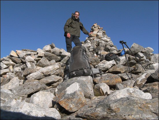
Leum Uilleim is very much in the middle of things with mountains in every direction. I didn’t stop long at the top as there was a strong, cold easterly wind and time was getting on. There’s a ridge running NE from the summit, the Sron an Lagain Ghairbh, down to Corrour Station where I hoped to camp, but I suspected the ground might be rough going, and not wanting to get involved in difficulties this late in the day I took the surer option of retracing my steps down to the pass between Leum Uilleim and Beinn a Bhric (a peak I had come over on my way to Leum Uilleim) and then following another ridge down to the NE, which my Harveys map showed a path on.
There was indeed a path and I found a campsite beside the Allt a Chamabhreac at 8pm.
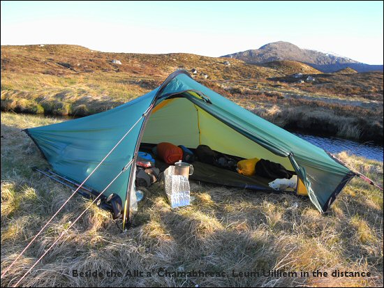
I was half a mile away from Corrour Station and just a few hundred yards from the railway line. Whilst eating dinner the sleeper train from Fort William to London slowly passed, tooting to me when I waved, and later on the evening train from Glasgow trundled past in a northerly direction.
My log says that I was writing it at 10pm in daylight. I had passed snow patches on top of Leum Uilleim and it still seemed cold down here, but actually “down here” was at over 1300’ (400m) and was even higher than our camp on day one on the Roshven ridge. The cold easterly wind made it even colder, and I was in my Marmot Helium sleeping bag (supposedly good down to -9 dgrees c) as soon as possible.
Day 06 Intro